Monthly production reports, filed electronically in all 30 states.
A pumper photographs the gauge. WellSite validates the volumes and builds Form PR - or your state's report - as EDI, portal JSON or the official form, ready to submit. Priced by reporting district. Unlimited wells.
production dataOperatorData room, interests,
evaluationReporter30 states.
Every report.
Press send.
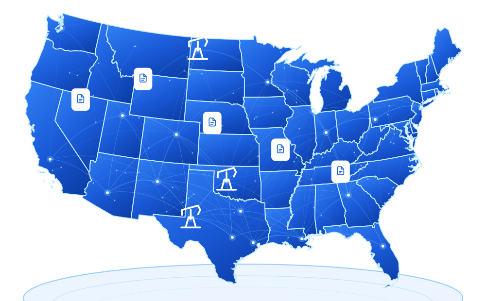
All 30 states.
data with photos,
OCR & validation.GIS mappingMap wells, leases &
infrastructure with
precision.Data roomManage interests,
packages and due
diligence.Production accountingBalance volumes,
allocations and
dispositions.Regulatory reportsCreate & file reports
for all 30 states.
EDI-formatted.Compliance & auditValidation, audit trails
& error checking
built in.Electronic filingFile direct with
state agencies.
Get confirmations.Team workflowRoles, approvals &
activity history you
can trust.
The whole operation, one login
Everything below ships in the workspace - most of it in every plan. Unlimited wells, always.
The morning gauge run becomes the monthly report
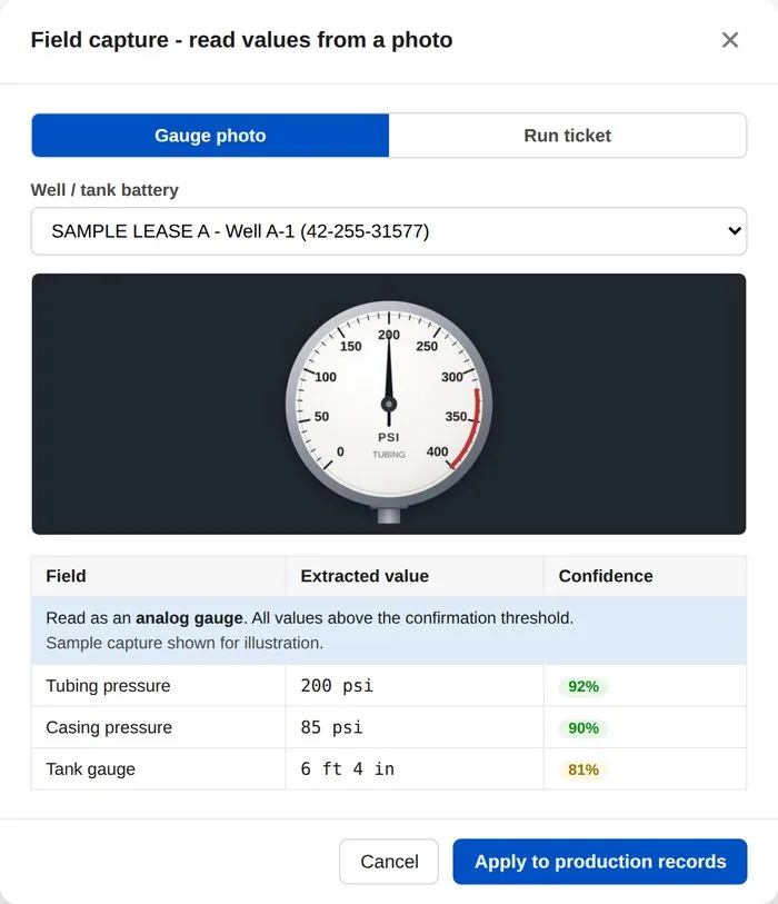
Your pumper opens WellSite Mobile, taps the well, and photographs the tank gauge or the transporter's run ticket. Document intelligence reads the meter, extracts the volumes, geotimestamps the capture, and queues it against the well record. You approve it once in the office - and it's already inside the production report. No transcription, no lost tickets, no month-end scramble.
- Rear-camera capture built for gloved hands and bright sun
- Every photo geotimestamped and kept in the pumper log
- Operator validation before anything touches a filing
Your wells on a live map, with 30 professional tools beside them
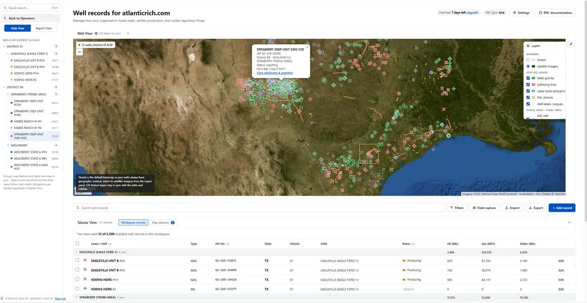
Wells import straight onto streets or satellite with API-standard symbology, live agency layers streaming around them - RRC wells, pipelines, injection, surveys. The docked Toolbox puts 30 geospatially enabled tools one click from the map: measure, buffer, spacing analysis, field summaries, exports - every result reported full-view and synced back to the map and your reports.
- Live state agency GIS with pan-and-zoom refresh
- Box-select any area into an interactive record table
- Field production summaries, spacing analysis, CSV / GeoJSON export
See what the field is about to do, not just what it did
Radar scores pad activity against a long-term baseline and flags likely reactivations before they show up anywhere else. Telemetry streams SCADA-grade rates, pressures, tank levels and alarms across every well. Subsurface renders your acreage as a 3D shared-earth model - formations, laterals, frac corridors - with 4D playback of drilling and production. All three ship in most plans, not as add-ons.
- Radar and Subsurface included with Flex
- Telemetry included with Exclusive
- One login, one dataset, zero integrations to babysit
Every report, in every producing state - never priced by the well
Thirty states, every production report, in the exact format each agency accepts: schema-checked X12 EDI where the state runs it, portal JSON for modern e-file, and faithfully populated official forms everywhere else. Add a well, add a hundred - your price doesn't move, because WellSite bills by reporting district, never by well count.
- All reports, all 30 oil & gas producing states
- Compliance Calendar derives every deadline from your own records
- Unlimited wells and field users on every plan
Priced by footprint, never by well count
One flat price for a reporting jurisdiction, mapped to how each agency actually organizes filings. Add a thousand wells and your bill does not move.
From the meter to the state in seconds
A pumper photographs the gauge in the field and the number flows through review into a real filing. No spreadsheet, no rekeying, no second system.
Every filing format on every report
EDI, portal JSON, and auto-populated official forms, all included on every plan. The state decides the format, not your budget.
Your subsurface in the map, in 3D and 4D
See the formations your wellbores pass through at true depth, drilling and production over time, drawn right over live satellite imagery. Not a separate geology package.
One workspace, from your agency number to a filed report
WellSite provisions your operator workspace straight from your agency number, maps every well over live GIS layers, extracts production from any messy file with document intelligence, and files EDI, portal JSON, or auto-populated forms - jurisdiction by jurisdiction.
The operator workspace, provisioned from your agency number
Sign up with your RRC, OCC, or state operator number - WellSite looks it up in the agency's public records and starts your workspace with the wells, leases, districts and filed production on file.
Geospatial Well View - 2D, 3D & 4D
Real USGS/NAIP satellite imagery and OpenStreetMap streets with GIS layers that assimilate to your focus state - plus a 3D subsurface view of formations and wellbores with 4D drilling & production playback.
Document intelligence & OCR
Upload production totals in any format - xlsx, csv, txt, multi-sheet and messy. Pumper gauge photos and transporter run tickets extract straight from a phone camera into reporting fields.
30-state compliance engine
Per-jurisdiction obligations, deadlines and a compliance calendar derived from the districts and well types in your data - updated the moment records change.
Channel-aware filing
EDI (X12 867) where the state runs EDI, portal JSON where a modern e-file system exists, Excel/.txt templates, or auto-populated forms - assimilated per report, per state.
Excel-grade tabular view
Your records behave like a workbook - sort, edit in place, import and export - while staying in sync with the map and sidebar three ways.
GaugeEntry - field to office
Pumpers photograph gauges and run tickets; WellSite maintains monthly totals and ties every capture to the production reports it feeds.
Live in minutes, not months
Three steps from sign-up to your first filing.
Enter your operator number
RRC P-5 in Texas, OCC number in Oklahoma, OGRID in New Mexico - WellSite looks it up in the agency's public records and provisions your workspace with what is on file.
See everything, geospatially
Your wells, leases and districts arrive mapped over satellite imagery with the state's public energy data as togglable layers around them.
Upload totals. File anywhere.
Drop in production files of any shape - document intelligence does the rest, and each report generates in the exact electronic format its jurisdiction accepts.
From the meter to the state, in seconds
The pumper reads the gauge. The office files the report. WellSite is the straight line between them, with nothing rekeyed by hand.
Pumper photographs the gauge
On the WellSite app, the pumper snaps the meter or run ticket. The reading is stamped with the well, time and location before it ever leaves the truck.
at the wellheadThe number reads itself
Document intelligence pulls the volume off the photo and drops it into the right production field. No transcribing digits into a spreadsheet at 6pm.
seconds laterThe operator approves it
Field entries land in a review queue. The administrator confirms them, and only then does the number enter the reports. Nothing files without a human sign-off.
one tapIt leaves as a real filing
The compliance engine already knows what the state wants. Generate the EDI, portal JSON, or auto-populated form and it goes out in the format that jurisdiction accepts.
same cycleOne compliance engine. Every state's format.
Thirty states, dozens of agencies, and no two of them accept a filing the same way. WellSite reads your data once and speaks each agency's language on the way out. Every filing carries a verifiable audit record - what was filed, when, from which readings, and who approved it.
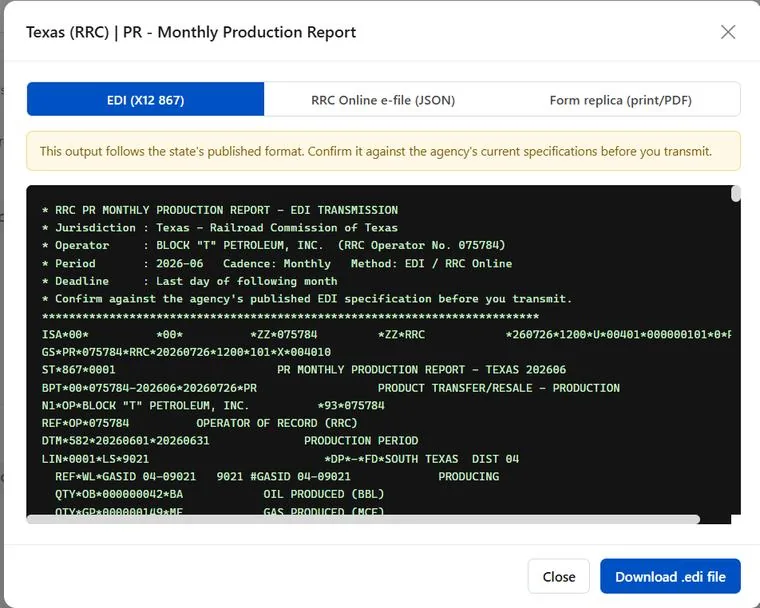
EDI, where the state runs it
Texas RRC and other EDI agencies get a valid, schema-checked X12 867 production transaction generated straight from your records, ready to transmit.
Portal JSON for modern e-file
States with a current online filing system get the JSON payload the portal's published schema expects, so the upload lands clean the first time.
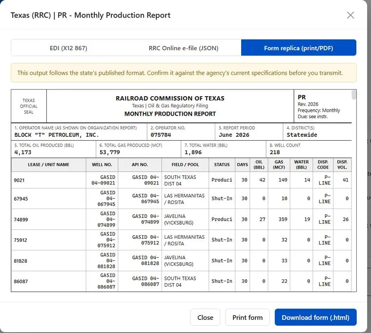
Auto-populated official forms
Where the agency still wants its own form, WellSite fills a faithful replica or the state's Excel or .txt template, populated from the same data. You review the hard copy before anything goes out.
You pay for your footprint, never your wells
Every plan is priced by reporting district and carries unlimited wells. No per-well fees, no per-form fees, no counting leases at renewal.
Essentials
- GaugeEntry - pumpers photograph gauges and run tickets, you validate, the report builds itself
- Compliance Engine - every deadline, form and rule tracked for the districts you operate in
- 30 states. All reports. Unlimited wells, every filing format
- GIS layers, Compliance Calendar and the WellSite Mobile app
Flex
- Everything in Essentials, unlimited wells
- Toolbox - 30 geospatially enabled tools, synced to the map and your reports
- Data Room - acquisition and divestiture packages: working and revenue interest per wellbore, volume-weighted net revenue, shut-in optimization ranking, P-4 transfer checklist, one-click package export
- GaugeEntry, Compliance Engine and every report
- Radar, Telemetry, Locate and Subsurface are Exclusive only
Exclusive
- Everything in Flex, unlimited wells
- Radar - predictive pad-reactivation detection
- Telemetry - live SCADA rates, pressures, tank levels and alarms
- Locate and Subsurface - box-select analytics and the 3D shared-earth model
- Priority support and filing reviews
Pay as you go
- One production report, one state, one period
- The same output: EDI, portal JSON or the populated official form
- Validation and disposition balancing before it goes out
- No subscription; move to a plan whenever you are ready
Being charged by the well or by the lease by your current vendor?
Cancel that agreement and your first two months of production reporting are FREE.
Bring us the cancellation notice and we provision your workspace the same day - unlimited wells, every report, in every district you operate.
Three parts, one workspace.
A pumper photographs the gauge. The reading lands on the right well record on its own. The monthly report builds itself and goes out in the format the state accepts. Nothing gets rekeyed between those steps.
Pumper
Your pumper photographs the gauge or the transporter's run ticket on the phone they already carry. The system reads the meter and attaches it to the correct well record automatically.
- Photo-to-data extraction from gauges, dials, meters and handwritten logs
- Run-ticket reading with auto-haul routing
- Tank readings, pressures and run tickets in one entry
- Shared tank allocation across leases
- iPhone and Android, with SMS capture where signal is thin
- Lives at mobile.wellsite.app - add it to the home screen, no app store
- Geo-tracking and geofencing on every capture
- Work orders, downtime and well tests
- Real-time sync and instant production visibility
Operator
Everything you own in one workspace, on a live map, with the Data Room for evaluating and moving a package of wells.
- Data Room: working and net revenue interest per wellbore
- Volume-weighted net revenue and cash flow
- SWD payback, decline curves and intervention scheduling
- Shut-in optimization ranking and rig routing
- P-4 transfer checklist and one-click package export
- Full GIS with 30 geospatial tools beside the map
- Unlimited wells, unlimited pumpers, on every plan
Reporter
Thirty states. All reports. All formats. Press send and wait for the email telling you your monthly production report was accepted.
- Every production report in all 30 producing states
- Schema-checked X12 EDI where the agency runs it
- Portal JSON for modern e-file systems
- Populated official forms for print or wet signature
- Production and disposition balancing before anything is sent
- Compliance calendar built from your own records
- Monthly reporting automation and 30-day summaries
The Railroad Commission no longer accepts paper P-18, PR, P-5, W-3C or W-3X.
Every one of those forms now has to arrive electronically. If someone on your team is still keying volumes into RRC Online by hand, that is the bottleneck now.
WellSite produces the electronic output for all five - straight from a pumper's photo of the gauge - and builds the monthly Form PR in the format the RRC accepts, checked and balanced before you submit it.
Your next Form PR is due at month-end.
Build it in WellSite.
Provision your workspace tonight - your first monthly production report can go out this cycle.